M40 GNSS Receiver

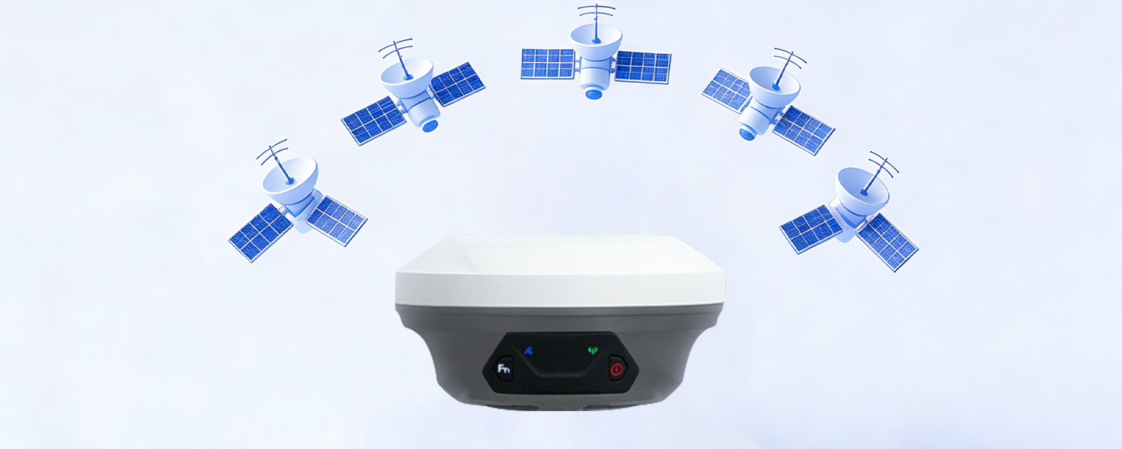
Full Constellation
Over 20hrs Operation
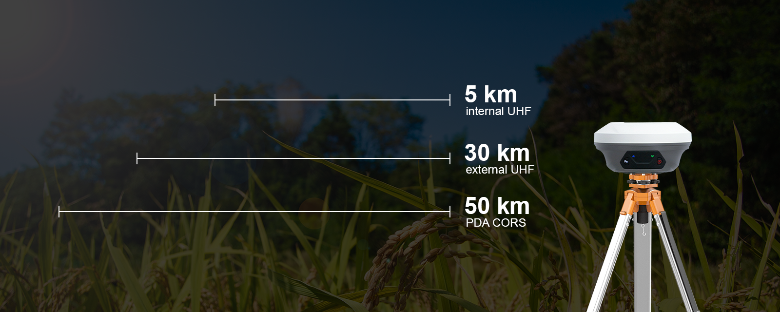
Long Baseline
60° Tilt 5s Initialization
IP68 Design
Smaller & Lighter
Full Constellation
M40 delivers rapid, stable fixed solutions in just seconds, even in challenging environments such as urban canyons, under tree cover, or areas with severe multipath interference. Featuring full-constellation robust signal tracking, advanced anti-interference capabilities, and a sophisticated RTK algorithm, it ensures high-performance positioning reliability.
Long Baseline
Supporting standard RTCM correction data transmission, the M40 achieves outstanding performance with a transmission range of up to 15 km in enhanced internal UHF mode, 20 km in external UHF mode, and over 50 km via PDA CORS mode under optimal conditions.
60° Tilt Five Seconds Initialization
Featuring an optimized next-generation IMU module, the system enables fast initialization in just 5 seconds, supporting tilt measurements of up to 60°. A single initialization maintains accuracy within ±2.5 cm throughout the entire work session, ensuring consistent and reliable performance.

Over 20 Hours Operation
M40 features an integrated internal battery design that enhances charging safety, waterproof performance, and internal structural efficiency. With a fast 3-hour charge via the Type-C port, it delivers over 20 hours of continuous operation. Additionally, it supports power bank charging, enabling convenient on-the-go power replenishment.

IP68 Design
M40’s rugged housing ensures reliable protection, safeguarding the device from damage even in heavy rain, dusty conditions, or if accidentally dropped onto concrete or into water. Built to withstand harsh environments, it delivers durable performance when you need it most.

Application

Digital Construction

Precision Agriculture
Technical Parameters
Accuracy
Standalone Horizontally
1.5 m
Standalone Vertically
2.5 m
DGPS Horizontally
0.4 m
DGPS Vertically
0.8 m
Static Post-processing Horizontally
2.5 mm + 0.5 ppm
Static Post-processing Vertically
5 mm + 0.5 ppm
RTK Horizontally
8 mm + 1 ppm
RTK Vertically
15 mm + 1 ppm
PPP Horizontally
5 cm
PPP Vertically
10 cm
SBAS
< 1.0m 3D RMS
Time Accuracy
20 ns
Tilt Surveying
< ± 2.5cm, With in 60° Tilt
Satellites Tracking
Channels
965
L-Band
< 30 s
Cold Start
< 20 s
RTK Initialization Time
< 1 s (typical)
RTK Initialization Reliability
> 99.9%
Re-acquisitio
< 1 s
Engine Model
BDS : B1I, B2I, B3I, B1C, B2a, B2b ¹, GPS : L1C/A, L1C, L2C, L2P(Y), L5, GLONASS : G1, G2, G3, Galileo : E1, E5a, E5b, E6*AltBoc*, QZSS : L1C/A, L1C, L2C, L5, IRNSS* : L5, SBAS : L1C/A, L5
User Interaction
Button
2 Buttons for Power and Function
Indicators
4 LEDs indicating battery/charging, satellite tracking, correction data transmission, and static recording.
Electrical
Power Consumption
2.0 W ²
Input Voltage
DC 9 ~ 28 V
Battery
6700 mAh (Over 20 hours working, Fast charge of 3 hours)
Physical
Size
Φ 133.5 mm * 67 mm
Weight
850 g
Storage
8 GB ³
Housing Material
Magnesium-aluminum Alloy
Speaker (Optional)
For voice broadcast of real-time status
Environmental
Working Temperature
- 40°C ~ 65°C
Storage Temperature
- 55 °C ~ 85 °C
Humidity
100% Non-condensing
Dust & Water Resistance
IP 68
Drop
Designed to survive a 2m drop onto concrete
Data Format
Data Output Format
NMEA-0183 , Binary format *.xyz
Data Update Rate
1 ~ 50 Hz selectable
Supported Protocols
Ntrip client, Ntrip Server, Ntrip Caster, TCP
Correction Data Format
RTCM2.X 3.2/3.1/3.0 , RTCM2.X 1004-1008/12/19/20/33/42/45
Communication
UHF modem 1 Working Range
Up to 15km with optimal conditions
UHF modem 1 Frequency Range
410 ~ 470 MHz
UHF modem 1 Channel Spacing
25 KHz
UHF modem 1 Transmit Power
0.5 ~ 2 W selectable
Bluetooth
BT 4.0 Dual Mode
NFC
Support NFC Connection
UHF modem 1 Protocol (RX)
RIMATLK, TRANSEOT, SATEL, TRIMMARK III, TRANSEOT, SOUTH, CSS
Battery
7-Pin lemo port for RS232 transmission and power supply * 1 ; TNC connector for UHF antenna * 1 ; Type-C USB port for static data download&firmware upgrade * 1
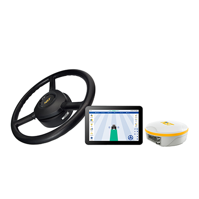
Products Matching

N600